
2007 Tropical Weather Review
2007 turned out to be a relatively quiet hurricane season for those with interests along the Eastern and Gulf Coasts of the United States. Below is a short summary of the season worldwide with select HurricaneMapping datasets from the most notable storms of the year to download for use in Google Earth and ESRI's ArcGIS.
Links to all available year summaries: 2010 | 2009 | 2008 | 2007
 Atlantic Basin
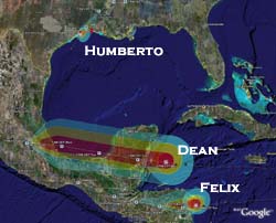
The Atlantic Basin saw a total of 14 named storms and 6 hurricanes in 2007, though Humberto was the only storm of hurricane strength to make landfall in the US. The two most intense storms of the Atlantic season—Hurricanes Dean and Felix—instead struck devastating blows to Central America and Mexico.
For a complete picture of the 2007 season, read the National Hurricane Center's Tropical Weather Summary.
Hurricane Humberto Special Advisory #4 (Thursday, 9/13/07 at 12:45am CDT) indicating that the storm has become a hurricane just before landfall:
(HurricaneMapping files for this advisory in KML format | Shapefile format)
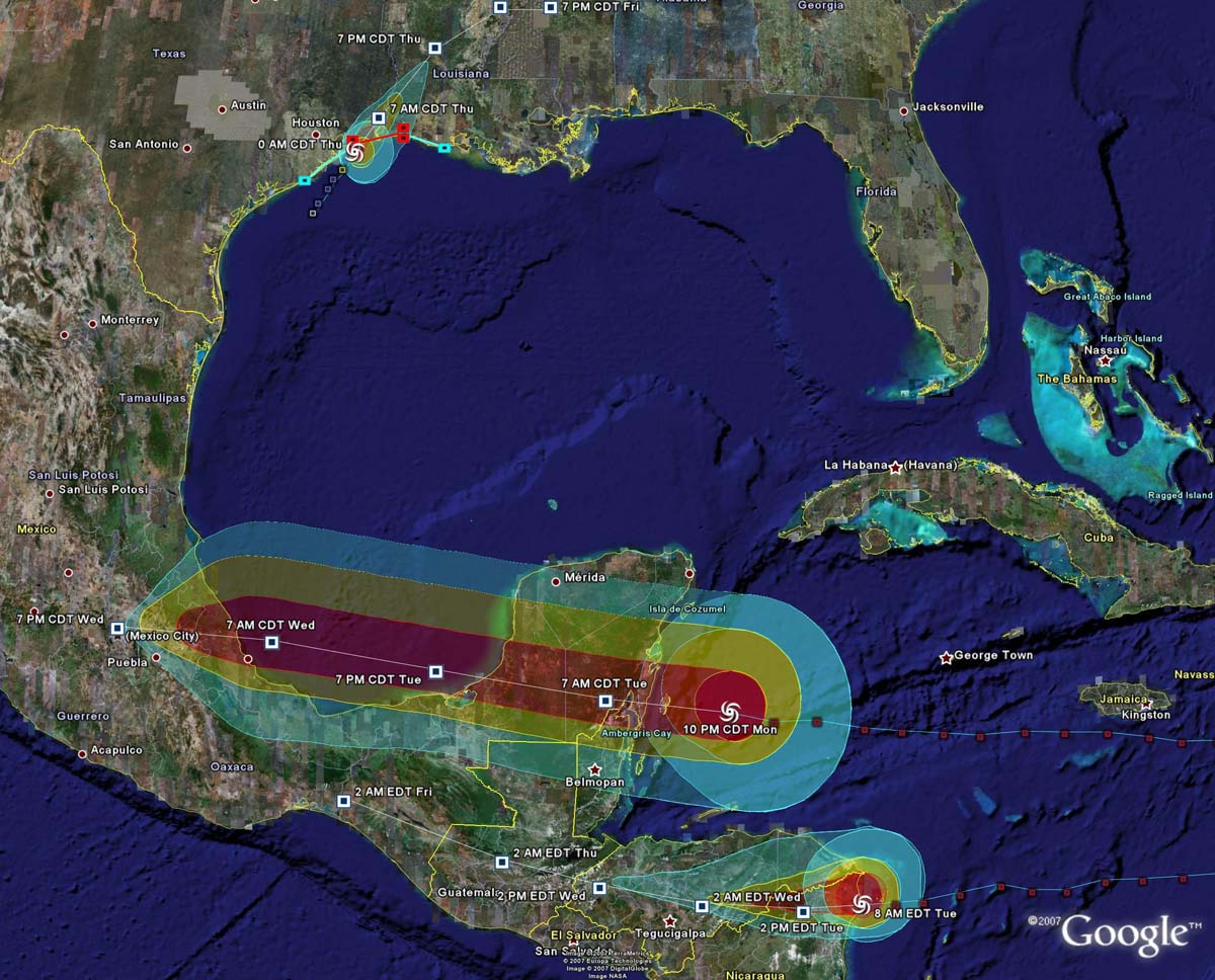
Hurricane Dean Advisory #32 (Monday, 8/20/07 at 11pm EDT) as the tropical storm-force winds of this Cat5 storm are just beginning to reach the Yucatan Peninsula:
(HurricaneMapping files for this advisory in KML format | Shapefile format)
Hurricane Felix Advisory #16A (Tuesday, 9/4/07 at 8am EDT) as the Cat5 storm makes landfall in northeastern Nicaragua:
(HurricaneMapping files for this advisory in KML format | Shapefile format)
 East and Central Pacific Basins
The East Pacific Basin’s most significant storm of 2007 was Hurricane Henriette which crossed the southern tip of the Baja Peninsula as a Cat1 and then entered the mainland Gulf of California coast as a strong tropical storm. In August, Hurricane Flossie bypassed the Big Island of Hawaii just 100 miles to the south.
Hurricane Henriette Advisory #20 (Tuesday, 9/4/07 at 8am PDT) just before first landfall on the Baja Peninsula:
(HurricaneMapping files for this advisory in KML format | Shapefile format)
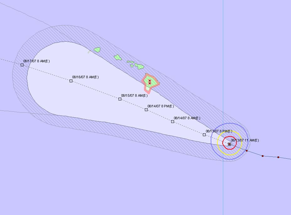
Hurricane Flossie Advisory #20 (Monday, 8/13/07 at 5am HST) with a hurricane watch issued for the Big Island due to potential threat from the then Cat4 storm still 36 hours away:
(HurricaneMapping files for this advisory in KML format | Shapefile format)
 West Pacific, South Pacific, and Indian Ocean Basins
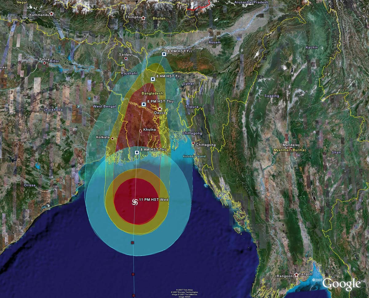
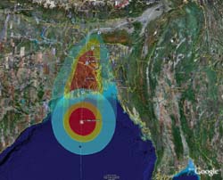
Typhoon activity in the West Pacific remained steady throughout the year, with 22 named storms through the end of November. Super Typhoon Wipha prompted massive evacuations in China in September when initially projected to strike Shanghai. And HurricaneMapping’s newly-added Indian Ocean coverage recently tracked the most significant storm of 2007—Tropical Cyclone Sidr which devastated the low-lying nation of Bangladesh in mid-November.
Super Typhoon Wipha Advisory #10 (Monday, 9/17/07 at 11am EDT) with projected 34kt winds arriving in 18 hours and a Cat3-4 storm track directly over heavily populated Shanghai:
(HurricaneMapping files for this advisory in KML format | Shapefile format)
Tropical Cyclone Sidr Advisory #12 (Wednesday, 11/14/07 at 9am GMT) as winds are arriving in Bangladesh and India:
(HurricaneMapping files for this advisory in KML format | Shapefile format)
_______________________________________________________________
Want more data from HurricaneMapping? Sea Island Software offers affordable subscriptions to KML and Shapefile datafeeds for live storm tracking and access to historic storm advisory datasets. Subscription Plans >>>
Need more information about HurricaneMapping's KML and Shapefile dataset specifications? Refer to the KML Dataset Description and Shapefile Dataset Description pages for details.