Wind Probabilities - An Important New Threat Assessment Tool
Part 1 of 3 - An Introduction
Tropical cyclone wind speed probabilities are a relatively new type of product from the Tropical Prediction Center/National Hurricane Center (TPC/NHC). Their purpose is to communicate forecast uncertainties not immediately apparent from the wind projections that the NHC presents in its forecast advisories.
To illustrate their utility, we'll first take a look at an advisory recently issued by the National Hurricane Center for Tropical Storm Noel (Advisory #11 from November 30, 2007 at 5AM Eastern Time). The screenshots on this page are of map layers produced by HurricaneMapping.com and displayed in ESRI's ArcGIS software. You can also download this zipped dataset of shapefiles for your own viewing in ArcGIS or other GIS program: Noel11_2007.zip
The wind swath depicted below is derived from the NHC's deterministic forecast of storm track and extents of winds of three categories (34kt or tropical storm force, 50kt, and 64kt or hurricane force) through a 72-hour period. The swath is probably fairly accurate in projecting what portion of Cuba will encounter tropical storm force winds because this is within the first 12 hours of the forecast period. The later hours are less certain however--What if the storm changes direction later than projected or grows in size or intensity? Though the wind swath seems to suggest that Florida will be spared, this cannot be assured.
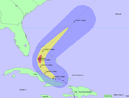
Figure 1. Forecast wind swath illustrates tropical storm force winds in blue,
50kt winds in yellow, and hurricane force winds in red.
The forecast error swath (sometimes termed the 'error cone' or 'cone of uncertainty') hints at some additional possibilities. This swath is derived from the NHC's accuracy in predicting where past storms have gone. The white area represents the region where the storm center is most likely to track and the striped zone indicates how far out tropical storm force winds could potentially extend. Should the storm track further west than is projected by the deterministic forecast (dashed line), then Florida could indeed receive some tropical storm force winds.
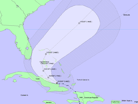
Figure 2. Forecast error swath illustrates the area where the storm center is most likely
to track within the next 72 hours and the additional area that could receive
tropical storm force winds in the striped region.
So what exactly are the odds of Florida receiving tropical storm force winds? With wind probabilities, we now have a bit more information to consider. In the illustration below, the 120-hour cumulative probabilities are broken down into 5 broad ranges: 5%, 10%, 20%, 30%, or 50% and greater. We see that Miami, West Palm Beach, and the Keys (in yellow) have a 20-30% chance of receiving tropical storm force winds. Further inland there is a 10-20% chance (green), then a 5-10% chance (blue).
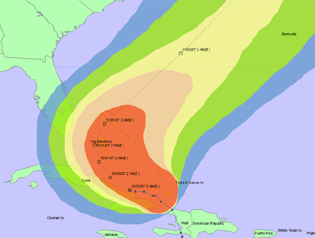
Figure 3. 120-hour cumulative probabilities for winds 34kts or greater. Probability
ranges are 5%(blue), 10%(green), 20%(yellow), 30%(pink), and 50%(red).
What about probabilities of higher winds? In the first illustration below, we see that Florida is reassuringly outside of the blue probability area for 50kt winds, meaning that the odds are very slim (less than 5%). And in the final illustration below, we find that even the Bahamas, in the direct path of the storm, have a fairly low likelihood (less than 20%) of encountering hurricane force winds.
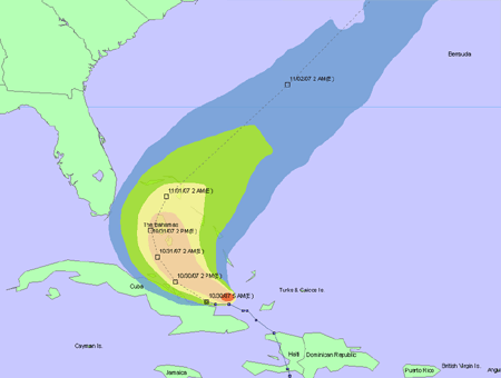
Figure 4. 120-hour cumulative probabilities for winds 50kts or greater. Probability
ranges are 5%(blue), 10%(green), 20%(yellow), 30%(pink), and 50%(red).
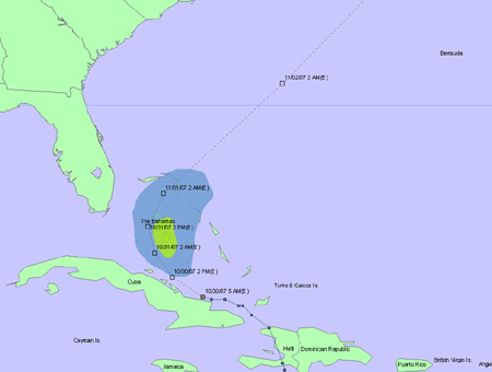
Figure 5. 120-hour cumulative probabilities for winds 64kts or greater. Probability
ranges are 5%(blue), 10%(green), 20%(yellow), 30%(pink), and 50%(red).
In the past, decisions whether or not to act upon uncertain wind threats have been subjective and somewhat arbitrary because they had to be made based solely upon deterministic wind extent forecasts and rough consideration of the average error swath. We believe that these new probability products can provide critical guidance for decision-makers facing potential hurricane hazards. Now that you've seen their most basic application, let's take a look at the variations of these products and get an understanding of how they are derived.
Part 2 - Derivations and Formats for Wind Probability Products >>>
