
Services
Overview of Services
HurricaneMapping.com is a data resource for users of two very popular mapping programs--Google Earth and ESRI's ArcGIS. Our subscription-based services deliver live hurricane, tropical storm, and typhoon tracking data quickly and efficiently to your desktop. HurricaneMapping's datasets contain many advanced map layers to help you analyze storm threats, plus presentation-ready symbology and labeling for quick and easy map preparation.
Continue on to see How the Process Works in this 4-part overview of HurricaneMapping's services, or select from links below to jump ahead to specifics about one of the two formats.
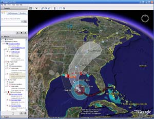 KML/KMZ format for Google Earth

Quicklinks:
- See a full-size version of this screenshot
- Download this KML advisory dataset for tryout in Google Earth
- KML Frequently Asked Questions
- KML File Format--Technical Documentation
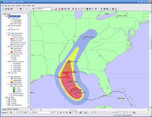 SHP (Shapefile) format for ESRI's ArcMap
Quicklinks:
- See a full-size version of this screenshot
- Download this zipped advisory dataset for tryout in ArcMap
- Shapefile Frequently Asked Questions
- Shapefile Dataset--Technical Documentation
3rd-Party Software
HurricaneMapping data also integrates with these weather tracking and risk assessment applications.
Visual Command Center
Visual Command Center helps organizations take command of risk by providing a real-time, common operating picture of a company's assets, personnel, supply chain and operations in relation to potential threats to those assets. It unites information on global sources of risk, like weather, terrorism, and natural disasters, with data from an organization's internal data stores and physical security systems on an interactive map and timeline. When a risk is detected near an asset or employee location, Visual Command Center automatically generates an alert and provides tools to assess whether the risk is a threat and take immediate action to minimize the impact.
For more information, visit idvsolutions.com.
Weather Defender®
Visit www.weatherdefender.com for more details and a free trial. The hurricane tracking layers are available through the main interface (subscription required).
Want to build your own application around HurricaneMapping's live datafeed? Options are available for enterprise application licensing.
Next Page: How the Process Works >>>